
|
|
|
| Use the text links for more information! |
No sidebar menus?, Click Here and re-select |
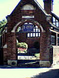
| Unpleasant
Meet your mates at Henry's Bar and then
head off towards town. Henry's Bar was completely re-furbished in the mid 1990's.
It used to be called The Mount Pleasant Inn, and from what remember, was not very pleasant. Still its pretty
good now!
Ancient Track
The only approach to the city without navigating steep gradients
was an approach from the north east along a narrow ridge between the Longbrook
and the Shitbrook valleys. This was so even before the Roman Occupation
just after AD50.
A pre-historic track wound down over Stoke Hill and along the Old Tiverton Road.
Henrys Bar stands about 400 metres south of this track on the crest of Pinhoe Road
which later became an important route to and from the east of the city.
The Mount Pleasant Tavern situated on the NW corner of the Mount Pleasant intersection
is documented as early as 1844, with its landlord Thomas Ronchetti living on the
corner from 1838.
|
|
| Intersection
Also at this road intersection stood the Withybridge or Blackboy Tollgate
until the turnpike trust ceased in 1844. You'll notice that the junction is staggered, a
right pain in the arse if you're driving. The boundary stones in the north and south corners
have ensured the junction has kept its original shape. In 1883, the St Davids Station horse drawn
tramway was extended as far as the Blackboy turnpike. This service went via Sidwell St and Bath
Road (now Blackboy Road). On the south east corner was the Blackboy Inn, "The Black Boy"
was said to have been the nickname for Charles II.
The Pub sign was changed to "Blackboy" after the restoration of the monarchy.
Mount Pleasant Methodist Church once stood
where the flats are situated now on the NE corner. This church was demolished in 1971 to make
way for the flats. Finish your pint and head down Blackboy Road to The Bowling Green.
|
| Ropemakers
This is a farly decent pub with a good selection of ales. Until the early 1990's it was known as The Ropemakers
Arms. The place was originally a Beer House and ropemakers premises and in 1881 it became the Ropemakers Arms,
the property having belonged to the same ropemaking family for over 100 years continuing their trade while
licensed to sell ale. It was always customary for individuals of the same trade to drink together, their
"rope walk" was nearby.
Next up is the Horse & Dray, further down Blackboy Road on the right.
|
|
During the mid C20th, a party was taking place in one of the upper rooms of The Ropemakers hosted by the landlord(s). The
pub was open as usual downstairs. There was plenty of singing, dancing and drinking going on when all of a
sudden there was an almighty crash from downstairs. The ceiling had collapsed onto the lower bar as a result
of all the jumping around upstairs.
The landlady arrived to find a scene of complete normality. A load of people sitting in the bar just carried on drinking their cider covered in plaster, dust and wood. They had of course picked the big bits out of their drink. Another time a regular had his ear bitten off and carried on drinking in the same inconsequent fashion. Thanks to Paul Andrew. |
| St Anne's Also around here are St Anne's Almshouses & Chapel. The medieval chapel is now used by Exeter's Greek Orthodox congregation and was rebuilt in 1418 by a Chantry Priest (John Wygar). After the dissolution, the Mainwaring family aquired the property for almshouses. These were the homes of eight poor men & women, each having two small rooms and a garden. The Civil War saw damage to the chapel with the Royalists holding this position. The Dean & Chapter retored the chapel in 1907-1910. The chaplain's house was demolished and two of the cottages were rebuilt in red brick and half-timbering. The porch was rebuilt in 1927. The two cottages at the rear have original C16th walls but were refurbished in 1986. The Cult of St Anne, mother of the Virgin Mary was introduced in the 1350's by Bishop Grandisson. St Anne's well, close to this site once supplied the Roman bath-house in central Exeter and also St Annes's Well Brewery, which used to stand below the Iron Bridge. |
 |
| Kempe
The fountain at the road junction Old Tiverton Road / Blackboy Road is a horse
trough and drinking fountain. It was given to the City of Exeter in 1879 by the ladies of the Exeter Branch of
the RSPCA and others in memory of William Kempe (1812-1871). He was a senior surgeon at the Royal Devon & Exeter
Hospital in Southernhay (now closed). The fountain was originally erected in front of the gateway to St Anne's
Chapel at the hospital but was moved to its present position when the roundabout was constructed in 1963. Just to
be anally complete, the new bogs were built in early 2004 to replace ealier ones dating from when the rounabout
was constructed.
Cross the Roundabout and head down Sidwell Street.
The large red brrick building to the right of the roundabout is James Owen House built in the late 1990's. It
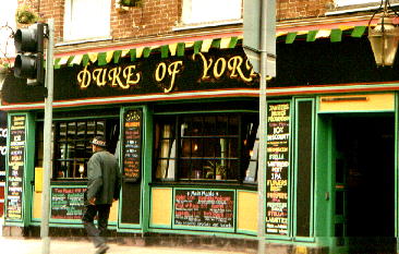
replaced Sidwell Street Motors and is a University owned apartment block. Your next stop is the Duke Of York.
|
| York Road and the corner The Duke Of York was first recorded in 1816 but prior to that had been known as The Dukes Head. Across York Road, on the other corner was the former site of the Acland Arms, which was known as the Turks Head between 1799 and 1812. It was called the Mail Coach before that. Evelieghs Garage and Sidwell Street Motors (I think) occupied the site after the pub. Now the garages have now gone too. The Kings Head stood on the other side of Sidwell Street. |
 |
|
A century and a half ago, York Road only went as far as Well Lane (now seen as Well Street). From this
point only a footpath led down to the Longbrook. The road in fact was named after the pub. Between 1853 and
1855 St Sidwells School was built on the corner of Well Street and York Road and at this point York Road
was extended to Hill's Court. The original part of the road was lowered for horse drawn traffic and this is
why the Duke of York is way above road level on it's York Road side.
The 1870's saw tall semi-detatched townhouses built along the new section of York Road, one of which became St Hilda's School. This house was used by soldiers during WW2, ammunition was also stored in the house. |
In May 1942, during the blitz, incendiary bombs fell on the
house causing the ammunition to go off, badly damaging the house and surrounding houses. Many were pulled
down, but one survivor is seen today with a sloping edge where the other half was cut away.
A park opposite had housed water tanks during WW2, St Sidwells School later aquired this land as playing fields and to build new classrooms. The Spiritulist Church was built in 1963 having moved from a location further down the road where it had occupied a Nissen hut built on the site of the demolished houses. |
| St Sidwella
St Sidwell's church over the road was destroyed in 1942 along with 800 houses
and buildings. The church was rebuilt in 1957.
There was some sort of Church on this site in the C11th but the fore runner of this current
church was built in C14th with much of it (excepting the tower and piers of the
arcade) were replaced in 1812.
|
Water Supply Exeter's underground passages were built to carry water from this spring and also a well (cathedral well, in Well Street). The Springs of the Long Brook were also diverted into the passages. A light one per cent gradient carried the water to the cathedral area. These passages are open to the public, the floors were once concave but have now been flattened to allow a safer environment for visitors. Parts of the passages have been dated as 12th century and were first recorded in 1226, but some like to think of them as Roman, built to carry water to the Bath-house found under the former Church of St Mary Major in Cathedral Yard. Householders along the route of the passages pushed pipes through the roof for a free water supply. Their attempts to steal water were thwarted when the supply was piped in the C14th. |
| The St Sidwell's Church of today is the fifth church on the site built in 1959 which replaced a temporary church. In 1549 the church was taken by the forces of the Prayerbook Rebellion and Sir Walter Raliegh's father who supported the new English prayer book was held prisoner inside the church. In 1646 the city was captured by the Roundheads and some Cavaliers were imprisoned in the church. Hugh Grove who was a leading citizen at the time was later executed (for plotting against the commonwealth) at Exeter Castle and buried at St Sidwell's. The church remained unchanged for many years. In 1999 as congregations dwindled, drastic action was taken and Ł1.5m spent turning the church into the UK's first Healthy Living Centre. This includes a community cafe, parent & toddler groups and workshops, and a community garden. Sessions are held for all sorts of activities including I.T. and free Internet access. |