|
|
|
| The Globe Inn | Ship & Pelican |
| The Golden Lion | The Windsor Castle |
| The Clifton Inn | The Royal Oak |
| The Honiton Inn | Wonford Inn |
| Mount Radford | The Flying Horse |
| The Heavitree | St Loyes |
| Use the text links for more information! |
No sidebar menus?, Click Here and re-select |
|
|
|
|
|
Workhouse
Newtown was rural two centuries ago, the first building on the banks of the Chute was the City's workhouse, this stood where the triangle car park now stands. In 1699-1707 a larger workhouse was built further up Heavitree Road (then named London Road). The old workhouse was repaired and extended and became a hospital known as City Hospital. Some of the Summerlands fields belonged to the hospital. Tennants of the fields included the Codrington family. In 1775, Bartholomew Parr Jr was appointed to Southernhay Hospital built in the 1740's and he married Maria Codrington, their son's surname was "Codrington Parr". Cholera
The Cholera epidemic of the 1820's and 1830's led to open streams such as the Chute being culverted and healthier homes built. The houses in Clifton Road were built in the 1830's however there were already some homes in the lower parts of Clifton Street, John Street East and Sandford Street. By 1850, these streets were completely built up with homes being built in Chute Street in 1851. During the blitz of WW2, many of the homes in Newtown were gutted and renovated after the war. |
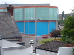
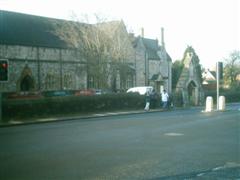
| Honiton Inn Next up is the Honiton Inn at the bottom of Paris Street. Make your way across the car park and up onto Heavitree Road, turn right towards the roundabout. The pub is on the second exit of the roundabout. On your way you'll notice the Pyramids Swimming Baths and Eaton House amongst other buildings. Two Victorian Terraces stand opposite the Swimming baths. Until 1830, Paris Street ran behind this block of houses, you can still see this old road along the edge of the car park. |
A new road was built in front of the houses in 1830, called aptly
New Road to carry horse drawn tram traffic with a little more ease. Eaton Place was originally built in the 1840's
and it is this that the Victorian Houses now represent.
Horse drawn trams ran down Paris Street and over New Road from 1882 until the electric tram system came into being in 1905. A tram depot was built opposite Eaton Place for the tram system in 1905 and after the last tram ran in 1931, this became a bus depot. The swimming baths were built next door to the bus depot in 1937. In 1975, all buses were run out of Bampfylde street with the introduction of the smaller busses we see on the streets of Exeter today. The first three houses of Eaton Place were demolished in the 1960's for the construction of Clarendon House (the DSS). In 1980, the Devon Community Housing Association bought the site of the old bus depot and demolished it, building Eaton House which opened in 1984. |
|
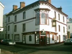
The Honiton
Inn was the only building left standing in Paris Street after the
blitz. The pub is currrently closed.
Until the late 1960's there were two buildings standing beside it. These and the Inn
survived the building of Western Way and the Paris Street roundabout in the late sixties.
They faced the new bus station which was opened in 1964.
The nearby concrete monstrosity housing the council (the civic centre) was built between 1965 and 1972. It took seven years to produce possibly the worst building in the City. It was designed by Exeter architect Vinton Hall, 5 phases using the modular principle. The Mount and Manor Office block and multi-storey built between 1988 and 1990 is far better. The building adjacent to the DSS office replaced a former Focus / MFI warehouse and was finished in 2005 as part of Exeter's City Centre re-development by Land Securities. The building incorporates car parks, warehousing and flats as part of the council's affordable housing policy. A cinema opened in this building on December 22 2006. |
|
Anyway, back to the Honiton Inn. It appears to have been built as a large house with a
door at the front (access is now via a side entrance). It was thatched in 1738 when many of the
buildings in Paris Street were burned down. It was up for sale in 1795 and a City valuation in 1838
indicates that it had it's own brewery and skittle alley. The current building however appears to have
been rebuilt in the early C20th using early English half-timbers. The pub sign depicts a square of
Honiton Lace. Honiton is also famous for it's pottery. Paris Street itself was once known as Shitbrook
Street. It ran down to Shit-brook. In 1663, Jenkin's History, records that the road was 'much out of
repair and full of dangerous pits'.
 |
 |
 |
| Summerlands
Neck your pint and head up Heavitree Road. On the left
just after Clifton Street you'll see Lower Summerlands. This row of houses
dates back to around 1814. Higher Summerlands were even more attractive
houses built prior to 1814, these were completely destroyed during the
blitz. If the Luftwaffe were after the Cathedral, Adolf should have given
them more carrots. You don't see Rudolf delivering presents to
the wrong part of town do you?
Built on the old site of Higher Summerlands is
Heavitree Road Police Station. This building was erected before the County and City
forces were integrated and was first used in 1959. There are magistrates
courts at the back which were built at around the same time but opened
a little later. |
|
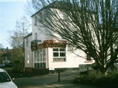
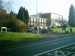
St Luke's Over the road are the Gothic buildings of St Lukes College, now part of Exeter University's School Of Education. The foundation stone was laid in 1853 and construction finished in October 1854. The playing fields which you'll pass later were enlarged in 1898 and the Chapel in 1912. Again severely bomb damaged, the college was re-opened in 1945 with further rebuilding taking several years. In 1978, St Luke's College became part of Exeter University. Turn down College Road just before the college on your right and head to the end of the road. At the traffic lights on the right you'll find the Mount Radford. Two bars are housed here, a quieter lounge bar on the the Magdalen Road side and a darker more lively bar with an entrance in College Road. Take your pick. Again it would be well worth having a few here because the next Pubs are in Fore Street Heavitree, another 10-15 minute walk. You are now in an area of the City known as St Leonards. This area of the City became important firstly because it borders the river and incorporated St Leonards Quay. Lady Isabella de Fortibus killed the Quay's trade when she built a weir at Countess Weir, thus ensuring all trade went through Topsham docks which her family owned. This mean't that St Leonards became a major traffic route between Topsham and Exeter until St Leonards Quay was returned to working order by the completion of the Exeter Canal in 1566. |
 |
Bankrupt
Do you remember Nick Leeson? Right, he was the man who was blamed
for bringing down Barings Bank.
|
|
The history of Mount Radford (also known as Radford Place) dates
from 1570 when Lawrence Radford Esq, a lawyer built himself a house and
called it Mount Radford. JBII transformed the old medeival residence into
a stately red brick Geogian mansion. He and his wife settled there rather
than at Larkbeare. With the purchase of the Manor & Lordship of Heavitree
in 1770, almost the whole of the parish of St Leonards and Heavitree was
in his possession. The death of John Baring II saw the Mount Radford and
Larkbeare estates pass to his son John Baring III, who sold them to his
cousin Sir Thomas Baring, 2nd Baronet of Larkbeare in 1817.
The Mount Radford was let to tennants and later sold and used as a college until 1902, when it was demolished. Barnardo Road and Cedars Road stand on the site. The grounds are now Central School's playing fields. Sorry but after all that, this pub is not it, but it is red brick and does look slightly Georgian in a red-brick suburban pub kind of way. The beers good though! Barings name was the oldest in City investment banking and was bought after it's collapse by ING of Holland for Ł1.00, however ING had to clear Ł660m losses. |
|
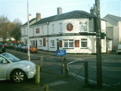
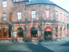
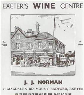 The advert above appeared in a City Council guide from the early 1960's. To complicate the issue, a map of 1904 shows there to have been a pub on this site. The arches suggest the building was built as a cellar or warehouse of some sort and was in place by 1873 (from a map). The premises were enlarged in 1890. |