|
|
|
| The Port Royal | Match Factory and St Leonards Quay |
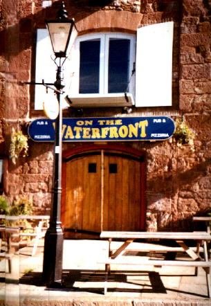
| On The Waterfront | Quayside History and the warehouses |
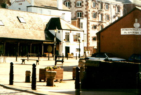
| The Prospect Inn | Quayside History and the warehouses |
| Riva | Custom House and Bonded Warehouses, Wharfingers Office |
| Havana at Restaurant 10 | Bonded Warehouses and Bridge |
| Harvester Malthouse | Over Cricklepit Bridge |
| Bar Venezia | Haven Banks |
| The Welcome Inn | Canal & Basin |
| The Double Locks Hotel | Exeter Canal |
| Use the text links for more information! |
No sidebar menus?, Click Here and re-select |
|
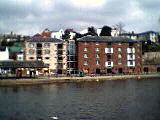
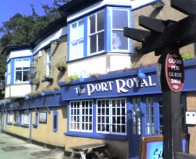
You've made it to The Port Royal by way of Colleton Hill,
Weirfield Road or through Trews Weir Reach. Get your pint in before checking out Trews Weir, the old mill and suspension
bridge. The pub was born in the mid 19th century, incorporating an old quayside warehouse and a row of canal worker's
cottages. The place was once the HQ of the Exeter Rowing Club until they moved over the river. The boat-house now makes
up the restaurant but the pub was briefly once known as the Boat House Inn.
 Jamaica? Port Royal was once the major commercial town of Jamaica and was notorious
for piracy, whoring and drinking.
Port royal gained a wicked reputation during the C17th as both the richest and wickedest city in the world,
notorious for displays of loose morals and vast wealth. Pirates were encouraged to frequent the City by the British
who paid them to attack French and Spanish shipping.
The 7th June 1692 saw the City virtually destroyed, sinking 25 ft into the Carribean. The City was built on
a sand spit and an earthquake liquefied the sand causing the city to collapse and the sea to overun the City.
A similar fate hit the biblical towns of Soddom and Gomora a few thousand years earlier. Soddom and Gomora were
also dens of iniquity and great places to be on a Saturday night. Their location is unknown but it is very likely they
were once on the shores of the Red or Dead Sea.
Never go drinking and whoring on a sand bar in an earthquake zone. You have been warned.
|
Kingston took over the role as commercial capital of jamaica and remains the capital today. Port royal was and is situated
at the western end of the Palisades sand spit (Dawlish Warren is a sand spit) that protected Kingston Harbour. The Harbour was
originally claimed by the spanish, with England aquiring it in 1655.
Pirates were welcomed to the City because the English lacked the manpower to effectively defend the City. By the 1660's most of the City's resident were pirates, cut-throats and prostitutes, Charles Lesley wrote, "Wine and women drained their wealth to such a degree that some of them (the pirates) were reduced to beggary. They have been known to spend 2 or 3,000 pieces of eight in one night; and one gave a strumpet 500 to see her naked. They used to buy a pipe of wine, place it in the street and oblige everyone that passed to drink." Following Henry Morgan's appointment as govenor, Jamaica passed anti-piracy laws and instead of being a safe haven for pirates, pirates were executed in Jamaica. 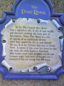 Pub Wall Plaque The town of Port Royal is featured in the Pirates of the Carribean films and there is also a honduran beer named, "Port Royal". Sup up before heading outside to take a look at Trews Weir, the suspension bridge and old mill. |
|
|
Dear Lord, Seeing as you got rid of Soddom, Gomorra and Port Royal, Please let me be Capt. Sparrow in "Pirates of the Carribean". I promise never to get pished again, and never to purposely embarass the wife in front of her friends. I also promise never to leave the Mother in law in the middle of Dartmoor again and will stop drinking scotch and snorting cocaine while driving. I wanna be in the bit where Kierra gets 'em oot. AMEN. |
|
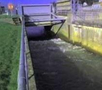
| Weir
Trews Weir was known as St Leonards Weir before utilisation and renovation by John Trew during the construction of
Exeter Canal in 1563. The weir was originally built of stakes and brushwood and
artificially rises the level of the river in order to feed the canal.
In February 2008, the level of the river above Trews Weir was lowered in order to work on the stonework and grout of the weir. The flow of
the river was diverted around the weir by opening some sluice gates bordering the overflow channel. The canal was filled using pumps. There are few
pictures below which will hopefully explain. The work was carried out by the City Council in response to recent flood conditions and alerts that had
seriously affected other parts of the country in recent years.
Mill
The leats seen beyond the Port Royal powered a mill (Trews Weir Paper Mill) whose origins are a little sketchy. It was
however a paper mill between 1834 and 1982 when it closed, the oldest parts dated 1780 as shown on the date stone on the front of the
building. From 1907 it was operated by John Pitt & sons producing paper. Before this it appears it may have been a cotton
spinning mill and later served as tennement housing for the mill workers. It has now been incorporated into the new housing
scheme (Trews Weir Reach, mid 1990's).
|
| Suspension Bridge
The bridge was constructed in 1935 to allow workers to cross to Willey's Foundry, it was refurbished in 1991.
Willey's engineering Works was closed in 1980. H.F Willey started his original foundry on Shilhay, but moved it to
Water Lane on the other side of the river in 1860. He died in 1894 and his son Alfred took over the business.
Willeys specialised in gas meters and when one of the employees Stephen Simpson invented a gas meter to work with coins in
a slot he was taken on as a director. Garton and King another famous Exeter Iron Foundry was next door to Willey's. They
specialised in man-hole covers and their name can be read all over the city. |
Past the bridge is Belle Isle park which was at one time a sewage works (shown on an OS map of 1930), after that it was
used by the City Council to raise plants for the city's flowerbeds.
Barges docked at St Leonards Quay carrying limestone from Babbacombe Quarry and coal from South Wales. The lime kilns these barges served are now within the grounds of Larkbeare House (the limestone wall up river from the pub, hides the latest version of Larkbeare House). They were in operation for about 140 years. The Quay at this point will have been dotted with stores and warehouses, the Port Royal Inn actually incorporates some of the old timber from an earlier quay warehouse on this site. |
|
Both warehouses are dated 1835, the left hand warehouse is constructed of limestone with dressings of red lava, the right
is of sanstone with dressings of the same stone and brick. The projecting eaves and the shallow buttresses of the facade
also differentiate the two buildings. The warehouses got a facelift in 1988 with the installation of the glass lift and
conversion to posh offices and the development of On The Waterfront.
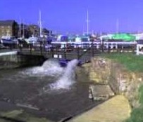
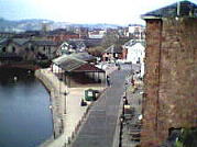
There is also an excellent view of the new suspension bridge (Cricklepit Bridge) from here. This is your route over to the other side of the river unless you use Butts Ferry. The bridge was designed by David Hubbard and opened on 29th June 1988. The ferry service dates back to 1641. The lamps on either side of the ferry are two of the original six that used to stand on the old Exe Bridge of 1905 and dismantled in 1973. On the Shooting Marsh Stile side of the river is the Canal Basin which once housed the Maritime Museum (now closed). There are still a few boats hanging around and its worth a look. |
|
Warehouse
The warehouses you are now sitting outside are the oldest warehouses of their type in the country and were at
their busiest in the mid eighteen hundreds when Exeter was the third or fourth most important port in the country. The BBC
series The Onedin Line used Exeter's Quay warehouses as a back-drop because Liverpool's waterfront was unsuitable in
1971 and 1976 when the series was filmed. The backdrop was Liverpool in the 1860's, the schooner, Charlotte Rhodes was
tied up at the Quay several times in 1971. The Quayside required an awfull lot of dredging in order to get the schooner
alongside.
Just to the left of the warehouses are the Prospect Steps and Watergate Path. These steps formed part of an ancient right of
way from Southernhay to the Quay. The steps date from 1835, the same as the adjacent warehouse. The walkway was renovated
in December 1990.
|
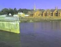
| You'll have realised by now that the river at this point has cut a steep cliff on it's city-side margin, leaving marshland to the west. The sandstone shelf on which the Quay is situated provided the perfect location to unload cargoes. The shipping trade finished years ago and was dealt a harsh blow when the railways reached Exeter in 1844. By the turn of the century trade was waning fast. In an attempt to win back trade from the coastal ports served by the railways a branch line was built into the Canal Basin over the river. |
|
The Quay took on its present look in 1564 around the same time that John Trew was building the first Exeter Canal. Boats used to moor up to 3 deep. The Weirs that can be seen on the Exe were built in order to raise the level of the river at Exeter thus allowing a good depth of water into the Canal. The head of the Canal is to the south of the Canal Basin over the river (take Butts ferry or walk over the suspension bridge). The canal is five miles long, 90 ft wide and 10 feet deep, large enough to carry 150 ton vessels and outlets at Turf locks on the Exe Estuary. Traffic along the canal was heavy until the mid 19th century after which time trade decreased and large debts for upkeep were amassed. On top of the cliff and slightly down stream of the Quay you'' ll also observe the the Georgian Houses of Colleton Crescent. These houses will have belonged to wealthy merchants having made their money from businesses based along the river banks. During Georgian times, Exeter was England's 6th largest city. |
 |