
|
|
|
| Use the text links for more information! |
|
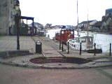
The basin and the piazza
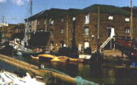
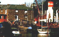
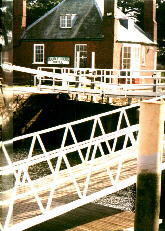
The Piazza Terracina overlooks the Canal Basin. Nip into the
Bar Venezia for a quick drink. The buildings around the Canal Basin
once housed the Maritime Museum, which had previously occupied the Quay Warehouses. These like the quay warehouses date
from the 1830's and are again of limestone and red breccia / sandstone. The cranes over the doors are still in place.
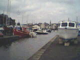
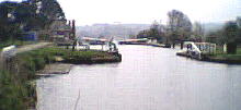
The Canal Basin is 900 ft long and 18 ft deep and was opened on Michalmas Day 1830. A turntable from the branch railway
now makes up part of the Piazza, the branch from the railway was built in 1867. The turntable actually displays a very
rare example of Brunel's
broad gauge line and shows that both systems worked in tandem at the canal basin. The SWR had the inner rails installed
to accomodate their standard gauge wagons, after the GWR had installed their broad gauge track.
The red brick building by the road is the former municipal electricity works opened in 1903 when electric trams were
introduced and closed in 1960. Before 1903, the site housed a Saw Mill and the electricity hall was in New North Road,
electricity having first come to Exeter in 1889. The citizens of Exeter elected for Electric Trams over motor buses in
1901. 70,000 GBP was spent on the generating station and 70k on the tramway. The tramway was required to make the generation
of electricity profitable for other purposes. A knock on effect was the replacement of Exe Bridge in 1903 with one that
was flat and could accomodate trams.
|
|
| Planner and the Resident
Work on the redevelopment of the canal basin has been delayed.
Exeter based architects, Kensington Taylor have drawn up
revised plans, after
the original plans were reworked several times. The original design included a white water
canoe course which has thankfully been dropped. I'm sure this will have caused
flood problems by simply reducing the ability of the flood-water to disperse and / or seep into the ground.
An environment for water based activities, commerce and leisure will be provided with
new facilities for existing water sports groups. The scheme also incorporates
residential housing.
A pedestrian bridge was proposed to link the Quay to the Piazza Terracina.
A visitor attraction will transform the former Electricity Generating building and the
former Maitime Museum building should accomodate one large office user. Cafes, bars and
restaurants will also be built.
The new scheme (2004) and how the area will look can be viewed here.
Alternatively visit the City Council Website available through the Local Links page. There was alot of local unrest
about the original plans.
|
| Kings Arms and Flood Relief
Head towards the road, turn left and keep going. Just before you get to the Welcome Inn take a look at the
locks at this end of the Exeter Canal (Kings Arms Sluice) and also the concrete wall forming the southern section of
Exeter's flood relief scheme
just opposite the Port Royal.
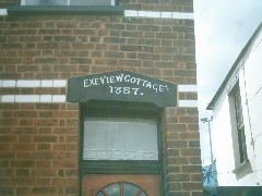
Before the flood relief scheme was completed, a house used to stand on the land between the relief channel and the
Canal. Strangely enough this was not the Kings Arms, but the lock-keeper's house. The sluice gate was named
after King James I. A marker post at the sluice marked the boundary
beyond which dues had to be paid to the port of Exeter. The post had the Kings Arms on it, and this is where the
'Kings Arms' sluice comes from. The house was demolished in 1969 by mistake. A house further down the canal was supposed
to have been demolished, unfortunately both were. See opposite (from an old postcard).
|
 During the later part of C17th and early C18th the canal was improved, the Kings Arms Sluice gate was replaced by a pair of gates to prevent flooding of the Canal from the river. Prior to this, many vessels had to wait at the sluice to gain access to the river or canal because the water levels were higher in the river. This side of the canal is a grey limestone building, presumably this was built around 1830 when the Canal Basin was built to house the gate keeper for the entrance to the basin. |
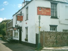
| Welcome in
The Welcome Inn was built around 1832 beside the canal and was originally
known as the Haven Banks Tavern or Inn. It became the Welcome Inn during the 1850's but was probably originally built
as a private residence quickly converting to a pub to take advantage of increasing commercial activity west of the river.
This place will take you back. Make sure you have some shillings and pence for the juke box. The pub was lit with free
gas supplied by its the neighbour, the Exeter Gas Light and Coke Company. Exeter pioneered the use of gas for light in
the West Country with the aforementioned company being founded on Exe Island in 1815. A rival company was established on
Haven Banks next door to the Welcome Inn in 1836.
May 1st 1939 saw the two companies merge and in 1870 the Exe Island site was shutdown. In 1903 a tramway was built to
ferry coal from the basin. The unsightly gas storage tank goes back to the days of Town gas which was produced from coal.
Nowadays of course we use natural gas from the Southern North Sea gas
fields. The gas tank is still used for storage of natural gas.
You've left the Welcome Inn and now you're back in the 20th Century, keep walking south along the towpath past the
football fields and changing rooms and eventually you'll get to the Double
Locks Hotel. If you make it inside
fifteen minutes try the Old Bastard from the bar, if it takes you longer then you are an old bastard at the bar. |
|
  |
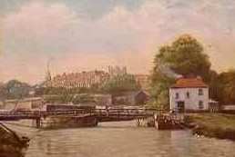
| Canal Trade was thus forced to pass through Topsham (he owned the port), where imports and other trade were greatly increased. However Isabella seems to have taken the blame. The City was eventually allowed to remove the barrier by Henry VIII, however the profile of the river had been altered to such an extent by the barrier that the river was never again navigable up to the Quay. In 1563 John Trew from Glamorgan was contracted to build a route towards it. The western side of the valley was selected to route the original canal rather than excavate the harder rocks to the east. By 1566 the canal was completed. This proto-canal started at Trews Weir. The canal proved impossible for ten ton vessels to use at all times and as a result trade again declined. The canal was widened, deepened and lengthened in 1698 to facilitate shipment for Exeter's many manufacturers. The contractor William Bayley fled after one year having embezzled funds and it was a further 26 years before the canal now 4 miles long and able to take 150 ton vessels was completed. |
Exeter's importance as a centre for the wool trade declined and along with the use of the canal.
The growth in the industrial use of coal from 1791 saw the canal become important once again. The canal was extended
again to it's present length of 5 miles in 1827 by James Green, the new outlet being at Turf on the estuary. Larger
vessels plied their trade along the 90 ft wide, 14 ft deep canal until the middle of the 19th century. The
Canal Basin
was added in 1830, after which time trade again subsided and large debts were unavoidable for upkeep. There were
stables along the canal at the City Basin, Double Locks and at Turf. These housed the horses employed to pull the barges.
For more detailed information on the development of the canal, Click Here. |
 |
An original Double Locks Hotel or lockhouse had been built in 1701 after the new locks had been installed. The Turf Locks Hotel at Topsham was built by James Green in 1827 when he extended the canal, he also extended or re-built the Double Locks Hotel. If you look closely at the brickwork on the Double locks Hotel you'll notice two types of brick suggesting rebuilding using some original material. The smaller and uneven red bricks are Tudor bricks or Dutch Clinker and most likely date from the original building (1701). The other type of bricks certainly appear to be of Victorian age, all the same size, and nicely finished. Dutch clinker were imported in large quantities into Topsham in particular as ballast between 1701 and 1730. Click Here for pictures. |
|
Together with this last canal extension, tow paths were added along the canal banks because horses were required to pull the larger vessels. Stables were built at the Double Locks Hotel with further stables at the Canal Basin and at Turf. A lock house had been built at Double Locks before the locks replaced the originals, There is no trace of this building, although the barn bar might be a candidate. The barn bar may have become the stables. The 'double' bit comes from the fact that two ships could fit in the same lock. Many ships used to stop here overnight before proceeding to Exeter. Once past the Kings Arms Sluice, they will have had to pay dues to the City. This money was far better spent on ale. The mast of HMS Exeter (which took part in the Battle of the River Plate) forms part of lock gates.
Notice the current wooden mitre posts and balance beams. Gate paddles to let water in and out of the lock are operated by hand windlasses. Smaller craft by-passed the lock altogether. Rails ran parallel to the lock which once carried a wheeled truck for the transport of these craft. Immediately outside the Inn is a mounting block possibly used in conjucnction with the truck and rails for lifting smaller craft. Stuart Callon Copyright ©2002 - 2005 |
|
 This place and the Wellhouse have got the best selection of beers in the city. There is a good case for making this your local.
Unfortunately its a real pain in the ass to get to on foot. Still at least you can walk off the gut.
This pub was CAMRA Pub of he Year in 1989 (South West Region), there are loads of good real ales to keep you going and
if you've got any louts with you then they can also drink. There is a good selection of bar food that you can order at
the hatch in the room adjacent to the bar. As you will approach the Pub you'll have passed the Locks on the Canal. Out
at the back is an adventure play area and barbeque area open in the summer. This is a great place to spend a summer
Sunday afternoon and evening. If you have kids they'll enjoy themselves too.
This place and the Wellhouse have got the best selection of beers in the city. There is a good case for making this your local.
Unfortunately its a real pain in the ass to get to on foot. Still at least you can walk off the gut.
This pub was CAMRA Pub of he Year in 1989 (South West Region), there are loads of good real ales to keep you going and
if you've got any louts with you then they can also drink. There is a good selection of bar food that you can order at
the hatch in the room adjacent to the bar. As you will approach the Pub you'll have passed the Locks on the Canal. Out
at the back is an adventure play area and barbeque area open in the summer. This is a great place to spend a summer
Sunday afternoon and evening. If you have kids they'll enjoy themselves too.